When: 08-Apr-2019

Summary

  • Section: Camp Los Perros – Camp El Paso
  • Distance: 8km
  • Duration: 3h, no breaks due to weather
  • It’s about 620m of elevation gain within 5km up to Paso John Gardner. From there you drop by 700m of elevation within the final 3km down to Camp Paso. Next to day 7, which included the Británico lookout for us, this will be the steepest it gets throughout the whole circuit.
  • If you’re lucky with the weather, you will have some mesmerising views all day.
  • This section is well-marked. Due to a snow storm on the pass some of the markers were barely visible.
  • Camp Paso only has basics: a kitchen area that is half open and a hole in the ground as toilet.
  • Just a few minutes from Camp Paso on the way to Camp Grey, there is a viewpoint. If you have a night at Paso, make sure to check this one out for sunset or sunrise.

Difficulty Rating

Below is my personal grading of the track including some key points. Check out the intro page to the SB scale here if you want to know how I do the rating.
The overall difficulty rating for this track is (with 10 being the hardest): 5.6 / 10
This is made up of the following categories:

Category A: General - 5 / 10

Distance: 8km
Duration: 3h
Elevation gain/loss: 620m up to the highest point of the pass, 700m down to Camp El Paso

Category B: Terrain - 6 / 10

The first couple kilometers of this day’s hike started out with a walk through forest.
Above the tree line the terrain was mostly made up of rocks and scree.
From there we were facing a snow landscape. The higher we got the more snow, the more slippery.
Some of the markers painted on rocks were covered by snow.
On the way down from the pass the landscape again changes from rocks to forest.

Category C: Weather - 8 / 10

Soon after we've started walking that morning, it started raining. Being more or less protected from the weather by trees this changesd once we hit the tree line.
After that rain turned into snow. Visibility worsened getting closer to the highest point, Paso John Gardner.
Only every other marker was visible. We were the first ones walking that day, so no footsteps made up a possible path.
With elevation the wind became stronger, too.
We only realised that we must've crossed the pass when we start loosing elevation.
It was a bit like the first day but less wind, more snow, colder.
Once we reached the tree line on the other side visibility increased, snow turned into rain again.

Category D: Special Conditions - 5 / 10

Backpacks are getting lighter and our backs stronger by the day.
Still, heavy backpacks in combination with the sight and slippery underground made the track a bit more challenging.

Category D: Special Conditions - 4 / 10

We're getting more and more used to the load we are carrying every day.
Christian had some trouble with his ankle this day. A small break here and there may have helped against his pain.
Due to weather we just weren’t able to have any breaks without cooling down. So we pushed through.

My Experience


Part of today is reaching the highest point of the whole track, Paso John Gardner. When we leave camp, it’s raining slightly. Not too much but enough to get soaked while we're walking.

The higher we get the more the rain turns into snow. Once we reach the tree line everything around us turns white with more coming from the sky. Some markers for the path are barely visible. Darryn later tells us that he followed our footprints because he could hardly see any markers.

We must’ve picked the perfect day to cross this pass. We will later find out that the hikers, who crossed the day before, as well as the ones who did the crossing the day after us had super nice sunny weather. Mesmerising views of mountains and the massive ice field inclusive.

You get a glimpse of our views from the videos. We can see for 50m ahead, at the most. We only realised that we’ve crossed the pass already because we felt that we were going downhill instead of up. We keep walking without any breaks because as soon as we come to a halt we get cold quickly.


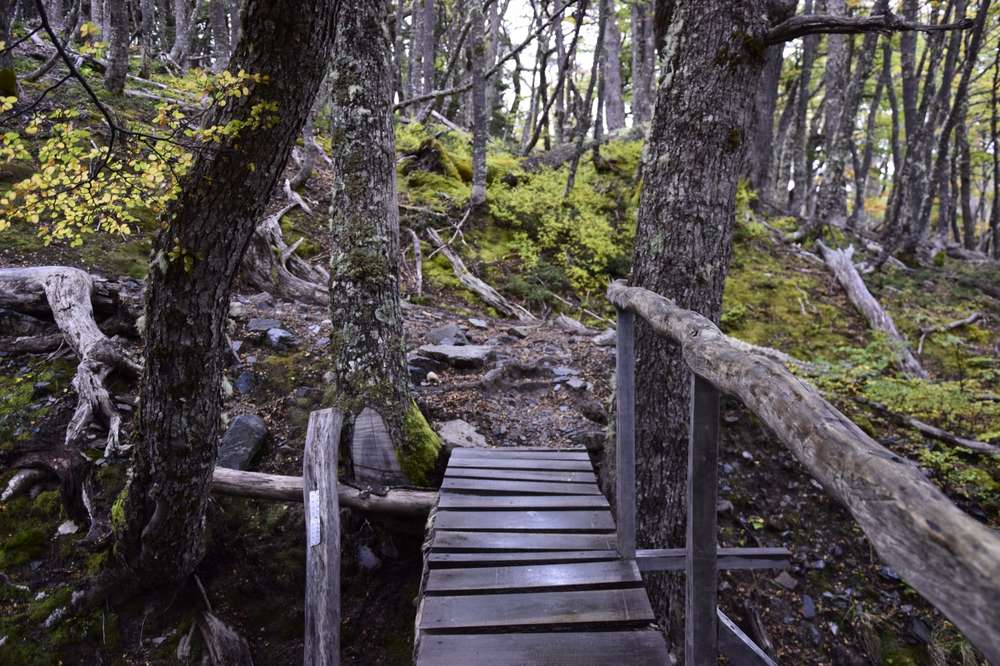
Once we reach the tree line on the other side snow becomes rain. All the white around us disappears into a rainy, green autumn forest scenery. Beyond the trees we can soon see a huge blue mass shining through. My mind was writing it off as a huge lake at first, not giving it any more thought.

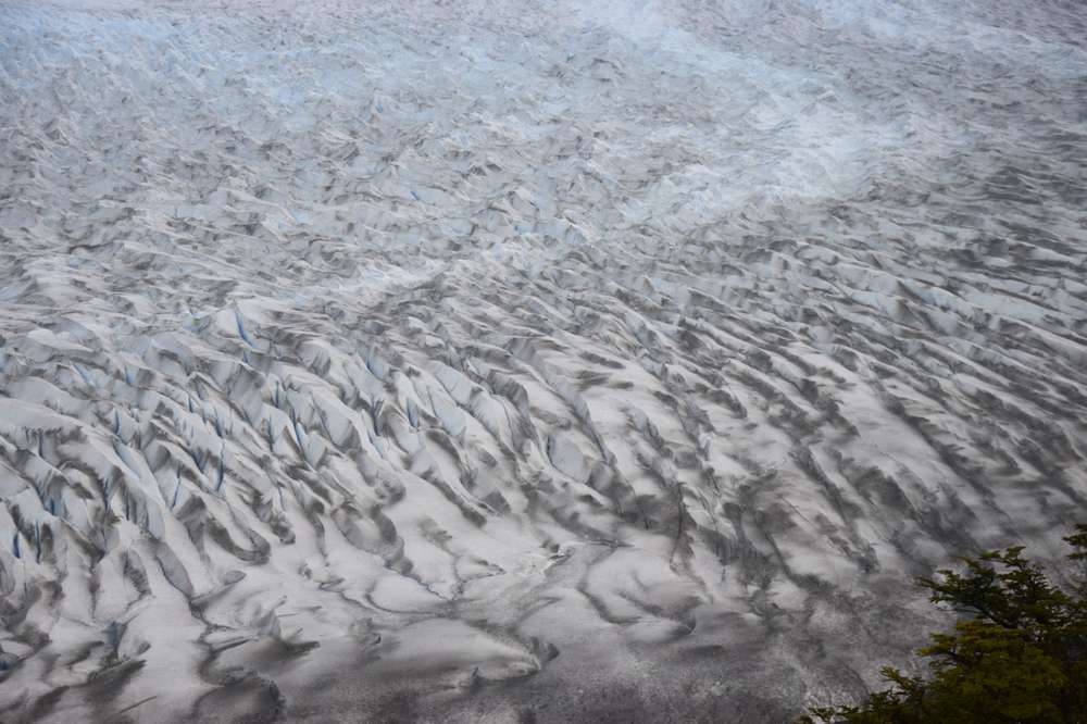
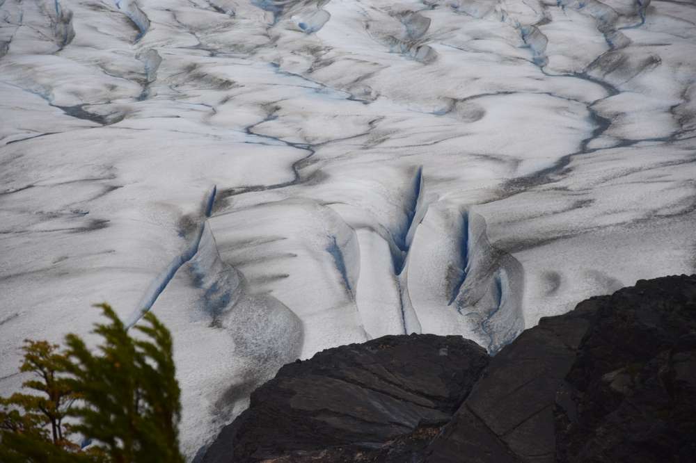
The closer we get, we realise that this huge mass is a glacier: the Grey glacier. Part of the Southern Patagonian Ice Field, the second largest adjacent ice field of the world outside of the poles. It’s the first time I’ve seen something like this. It leaves me speechless, overwhelmed, utterly humbled, full of gratitude. I'm hiding it but the sudden rush of emotions waters my eyes a little bit.

With good weather this spectacular site is already visible from the John Gardner pass, including beautiful mountain ranges surrounding it. We had zero visibility at the top. But since we had absolutely no idea what was around us and went into all of this without any expectations, we also had no idea that it would even be possible to see the glacier from up there.

Until the hikers we meet in Camp Paso show us pictures from their crossing the day prior to this one. It does feel a bit like a slap in the face at first, looking at their pictures. But in the end it was good exactly the way it happened.

The crossing was still kind of cool, reminding me very much of the first day. This time without our ridiculous mistakes and, believe it or not, a bit of fun.


Back

Leave a comment*

(*Please see A word or two.)